
The first freight train from Xi’an arrived Sunday at the Aprin dry port near Tehran, marking the consolidation of the China-Iran rail corridor that promises to reshape the Eurasian trade map.
This new overland route represents much more than a logistical alternative, it is a direct challenge to the US ability to control global trade flows through strategic points such as the Strait of Malacca.
The rail corridor drastically reduces transport times between China and Iran from the 30-40 days required by the traditional sea route to just 15 days overland. This competitive advantage is particularly relevant in a context where global supply chains are looking for more efficient alternatives that are less vulnerable to geopolitical disruptions.
Since its commissioning on July 21, 2024, double-load freight trains have been running between the two countries, bringing the reality of the planned China-Iran-Europe rail corridor closer to reality.
Geostrategic impact
Aprin’s CEO stressed that this inland port will not only reduce transportation costs, but will significantly reduce reliance on congested coastal shipping routes traditionally controlled by Western powers.
The initiative accelerates Chinese exports to Europe while expediting the flow of Iranian oil to China, deliberately avoiding choke points under U.S. influence.

New arteries of independence
On May 12, officials from Iran, China, Kazakhstan, Uzbekistan, Turkmenistan and Turkey met in Tehran to accelerate the development of this transcontinental rail network that will connect Asia to Europe.
The participants agreed on joint tariffs and operational standards to boost trade and regional connectivity, Tasnim News agency reported.
This multilateral coordination is evidence of the construction of an alternative trade bloc that challenges the traditional Western-dominated economic architecture.
The China-Iran railway project transcends the commercial dimension to become a tool for geopolitical reconfiguration. Both countries are building what analysts describe as “steel arteries of independence” that Washington can neither patrol nor control.
This infrastructure represents a key component of China’s Belt and Road Initiative, which seeks to create alternative trade corridors to those historically dominated by Western powers.
That new silk road map goes pretty hard.
It’s beautiful. It gives me the urge to go buy a couple of camels and lead a caravan across the desert.
How is it that the map in the article shows no routes that actually pass through Iran? What am I missing?
You are right. Telesur made a mistake there. I found another map that does include Iran and it may look like this one:
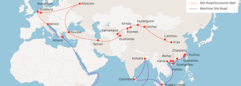
One thing that i find very striking is that the new route only goes north of the Tian Shan mountains. Ancient silk road trade routes more often went with the southern option through the Tarim basin:

I wonder why this is. It might be smart for China to diversify the routes in case one gets disrupted for some reason. Plus it would have very beneficial development effects on cities like Kashgar.
Maybe the mountain passes are hard to develop transporation infrastructure through? Or maybe China wants to avoid Kyrgyzstan/Tajikistan for some reason? There has been some instability there recently.
Maybe the mountain passes are hard to develop transporation infrastructure through? Or maybe China wants to avoid Kyrgyzstan/Tajikistan for some reason? There has been some instability there recently.
Great questions and sadly I don’t know enough to make an educated guess to answer them. 😞 Hopefully, another comrade could probably share a possible hypothesis here.